What Is Satcat AI
Satcat is a cutting-edge platform crafted by Kayhan Space, designed to revolutionize how users interact with satellite data. As a unified tool, it fills a significant gap in the space industry by offering a modern, user-friendly interface for satellite tracking and research. This is particularly noteworthy given the fragmentation of data across various sources like space-track.org and GCAT.
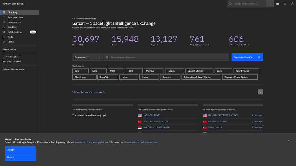
Satcat's primary purpose is to provide accessible and comprehensive satellite insights. With a robust database of over 60,000 objects and up to four years of historical data, it caters to a diverse audience, including satellite operators, astronomers, and space enthusiasts. The platform allows users to track satellites, including the International Space Station, in real time and predict visibility from specific locations. Furthermore, the 3D visualization features enable an engaging exploration of active satellites.
Beyond tracking capabilities, Satcat also empowers users to experiment with satellite data. It offers tools for loading and visualizing custom orbital elements, enhancing the user's ability to perform in-depth analyses and simulations. This makes it an invaluable asset for those in the academic, research, and commercial satellite sectors, providing vital insights and fostering innovation.
Overall, Satcat represents a significant advancement in satellite data management. By integrating various functionalities into a single platform, it ensures that high-quality, real-time satellite information is readily available to all, democratizing space data access and setting a new standard in the space technology domain.
Satcat AI Features
Satcat is an all-encompassing platform designed to track, research, and experiment with satellites and their orbits. Here are some of the key features that make Satcat a valuable tool for its users:
Core Functionalities
Satcat offers robust tools for satellite tracking and visualization. Users can:
- Track Satellites in Real-Time: Monitor satellites like the International Space Station and receive forecasts on their visibility from any location.
- 3D Visualization: View a 3D globe of active satellites to get a comprehensive spatial understanding of their current positions.
- Load and Visualize Custom Orbits: Users can upload their own TLEs (Two-Line Elements) and visualize custom satellite orbits.
Data Handling and Analytics
The platform is equipped with extensive data handling capabilities:
- Historical Data Access: Access up to four years of historical TLEs and orbital elements, enabling in-depth research and analysis.
- Search Functionality: Find satellites by various parameters such as owner, country of origin, launch date, and more, allowing for detailed data exploration.
Unique Selling Points
Satcat distinguishes itself from other resources in several ways:
- Unified and Modern Experience: While other sources provide scattered data, Satcat offers a unified platform with a modern user interface, making it accessible to a broader audience.
- Free Access: Satcat is available for free, encouraging exploration and interaction without financial barriers.
Satcat is designed to cater to a diverse audience, from satellite operators to space enthusiasts, making it a versatile tool in the space industry.
Satcat AI FAQs
Satcat AI Frequently Asked Questions
What is Satcat?
Satcat is a platform designed to help users track, research, and experiment with satellites and their orbits. It provides real-time tracking, 3D visualization, and access to historical data.
How can I track satellites using Satcat?
Satcat allows you to track satellites like the International Space Station in real-time and provides forecasts on their visibility from your location.
Is Satcat free to use?
Yes, Satcat is free to use for everyone, including satellite operators, astronomers, and space enthusiasts.
What kind of satellite data can I access on Satcat?
You can access up to 4 years of historical Two-Line Elements (TLEs) and orbital elements data on Satcat.
Can I upload my own TLEs to Satcat?
Yes, you can load your own TLEs and visualize your own orbits using Satcat's tools.
What search features are available on Satcat?
Satcat offers both basic and advanced search options, allowing you to search satellites by owner, country of origin, launch date, decay date, and orbital elements.
What is the Sandbox feature?
The Sandbox is a feature on Satcat that allows users to experiment and interact with satellite data in a flexible, exploratory environment.
Discover Alternatives to Satcat AI
Bot Hunt AI is the ultimate directory for exploring top-quality, innovative chatbots.
10/21/2024
SaaSy AI Trends is an innovative platform tracking SaaS growth through brand search analytics.
10/28/2024